CLIENTS

ABOUT
Polardot Solutions is a consulting firm based in Nairobi, Kenya that specializes in geospatial and information and communication technology (ICT) services.
The company offers a range of geospatial solutions, including drone and satellite mapping, surveying, location intelligence, cloud-based software development, and mobile app development for GIS data collection. We provide location data analytics to help clients make informed decisions.
Our goal is to create cost-effective, easy to use, and sustainable Geo-IT solutions which have a positive impact across both communities and businesses in Africa.
INDUSTRIESHOW WE WORK
Analysis of the Problem
- Define project objectives and requirements.
- Assess potential challenges and limitations.
- Identify key stakeholders and their needs.
Solution Design
- Select appropriate technologies and tools.
- Consider scalability, interoperability, and security.
- Collaborate with stakeholders to refine design concepts.
Data Collection & Integration
- Collect relevant geospatial data from various sources such as autonomous drones, earth observation satellite imagery,survey equipments internet of things(IoT) sensors, global positioning systems(GPS), airborne sensors, databases, and open-source datasets.
- Ensure data quality and accuracy through validation and cleaning.
- Perform spatial data processing and analysis.
Delivery
- Develop and implement the geospatial solution.
- Provide training and documentation for end-users.
- Iterate and refine based on user needs and evolving requirements.
Core Industries
Polardot Intellifiber for the Telecommunication Industry.
-
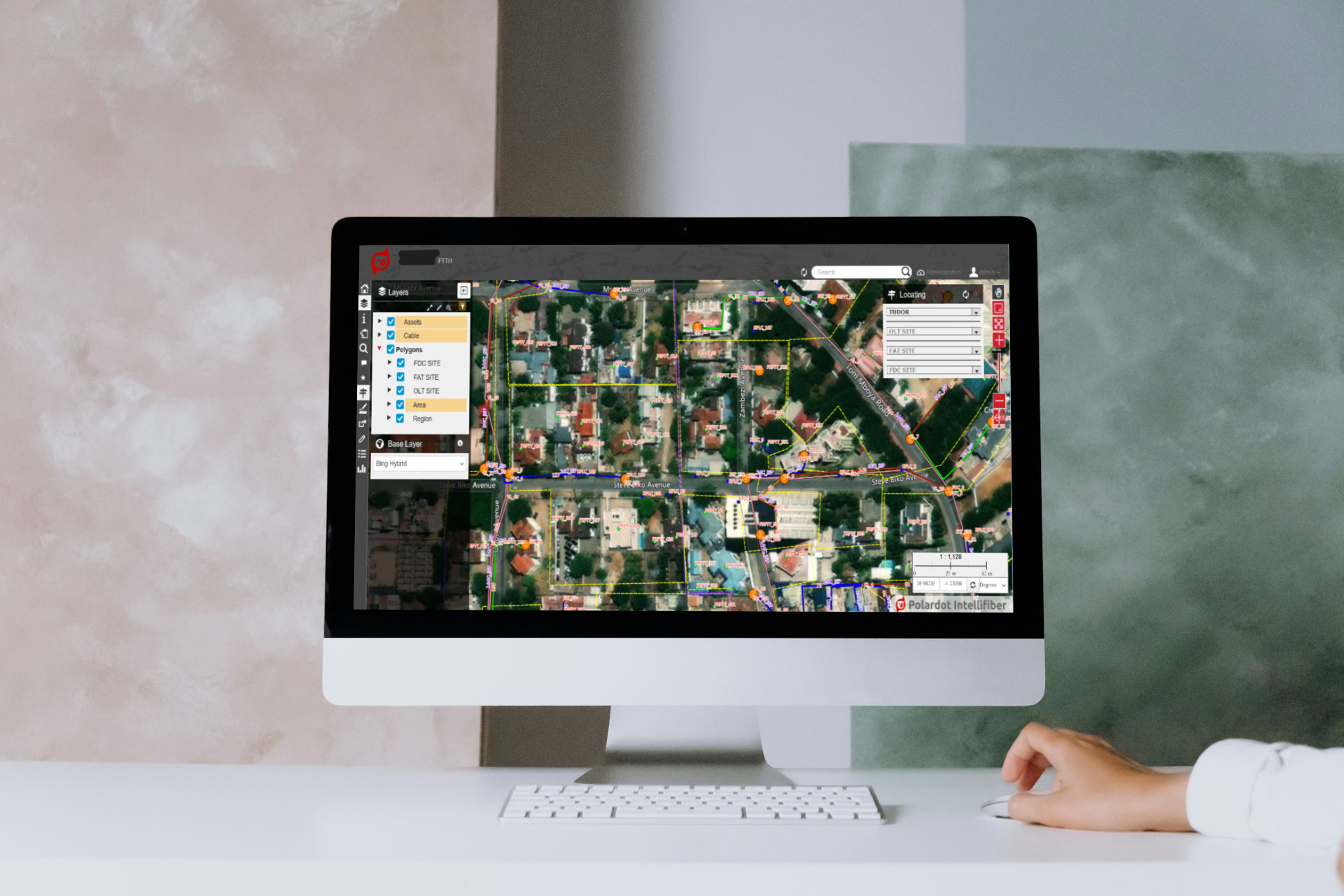
Polardot Intellifiber is a cloud-based fiber network mapping and management platform that simplifies the process of mapping, analyzing, managing, and maintenance of your FTTx networks to individual fiber level.
With our data collection mobile app and web portal, you can easily track, manage and maintain your fiber networks on the go. Our mobile app allows you to collect and update GIS data in real-time, while our web portal gives you a comprehensive overview of your network and allows you to access and analyze data from anywhere.
- Plan and construct a new fiber network architecture for a variety of situations, then estimate the asset totals.
- Track all field fiber assets’ status and performance in real-time in the office or on mobile devices, both online and offline, throughout the asset life cycle.
- Coordinate your maintenance and inspections, analyze them, and organize all procedures digitally.
- Increase inventory accuracy and reduce field asset theft by executing field asset inspections to verify inventory items utilizing the platform.
- Share data and maps in a variety of formats across field and office teams rapidly and effortlessly. data.
- Integration with existing asset management systems, inventory tracking systems, and multiple sources and formats of location data. data.
Uses of Polardot Intellifiber.
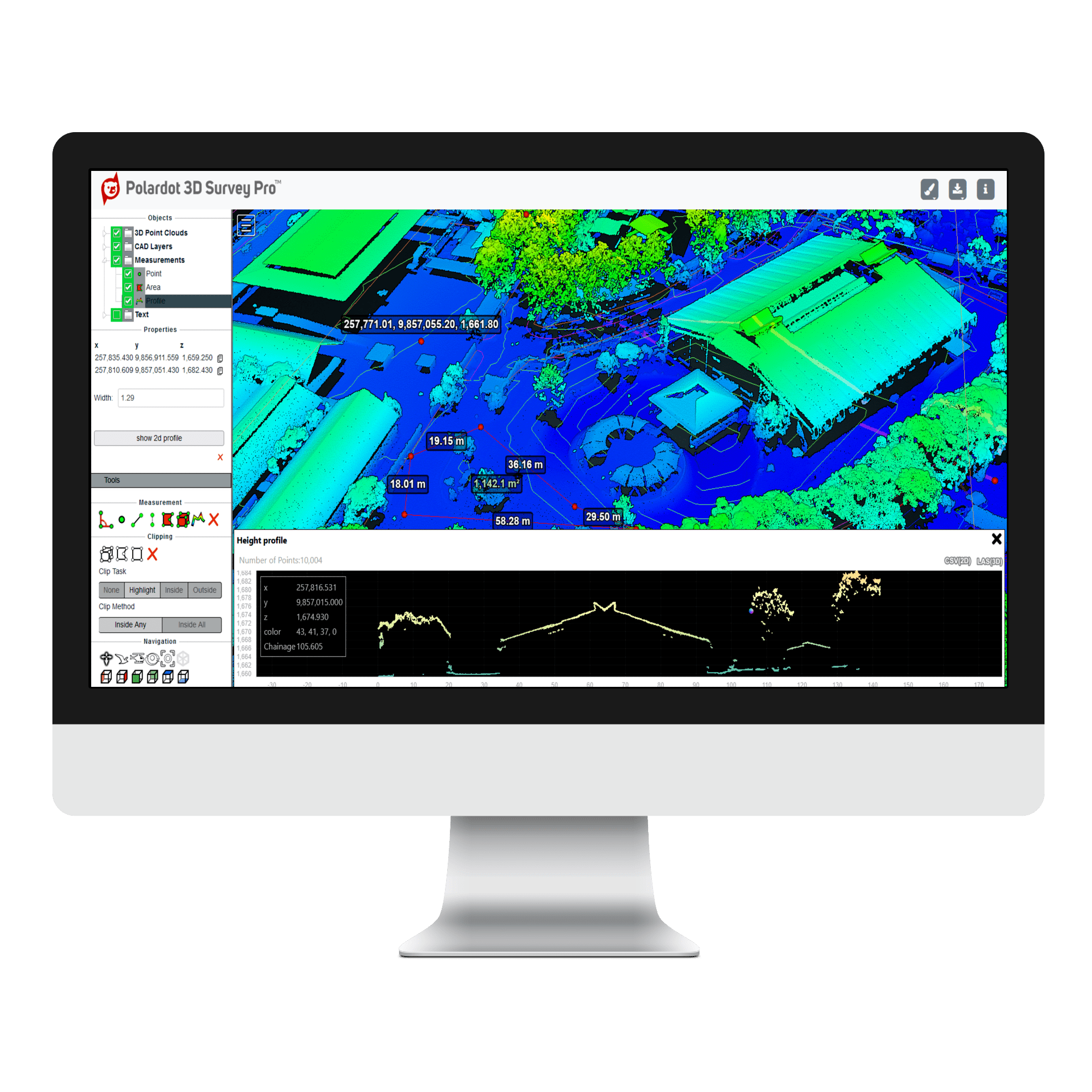
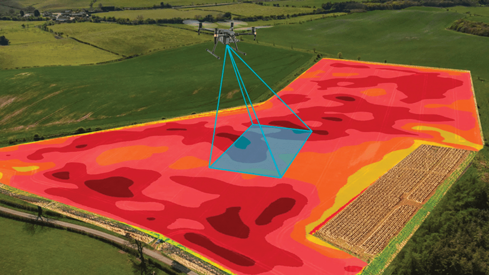
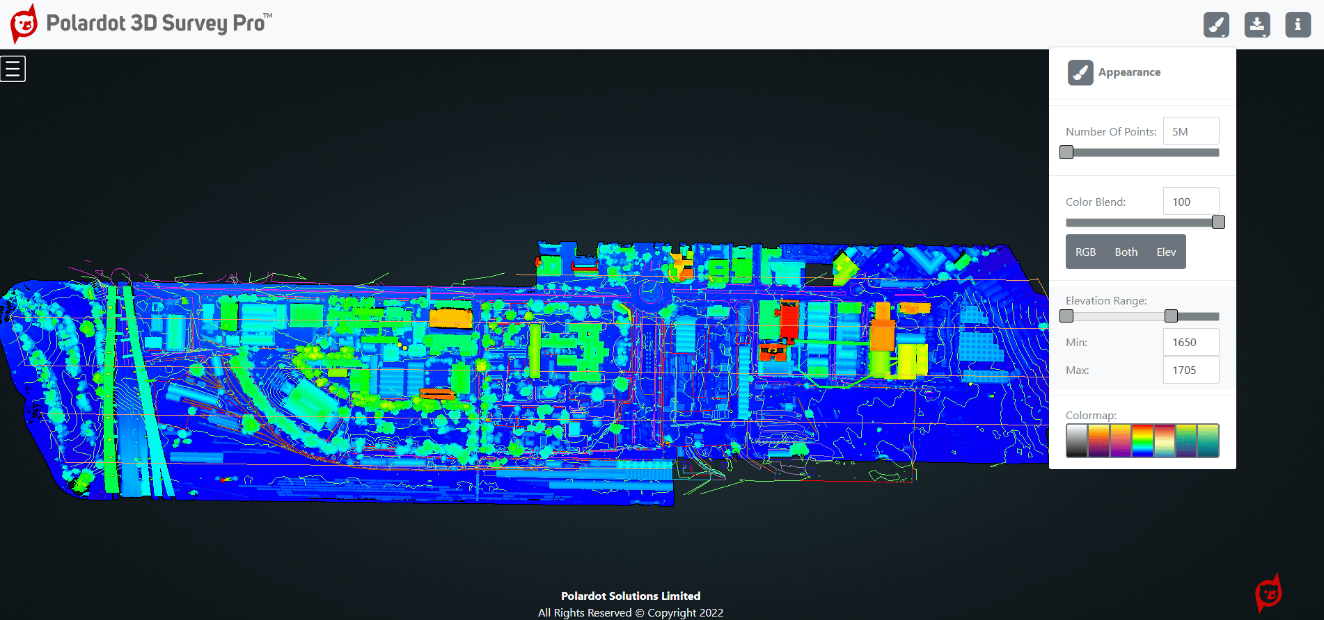
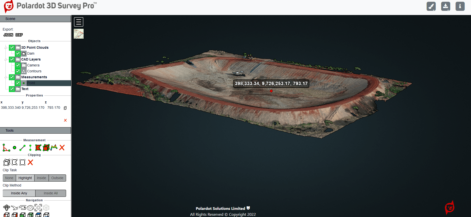
Drone Surveying & Mapping.
By use of drones mounted with LiDAR sensors and/or RGB cameras, data can be collected and analyzed for:
- Roads and Infrastructure Inspection & Topographic Mapping.
- Buildings Construction Mapping for design,progress monitoring & as-built verification.
- Stockpile and Volumetric Measurements.
- Land and Natural Resources Mapping Including Dams, Rivers and Lakes.
- Land Parcel Boundaries establishment & verification.
- Cloud based drone data storage and hosting.
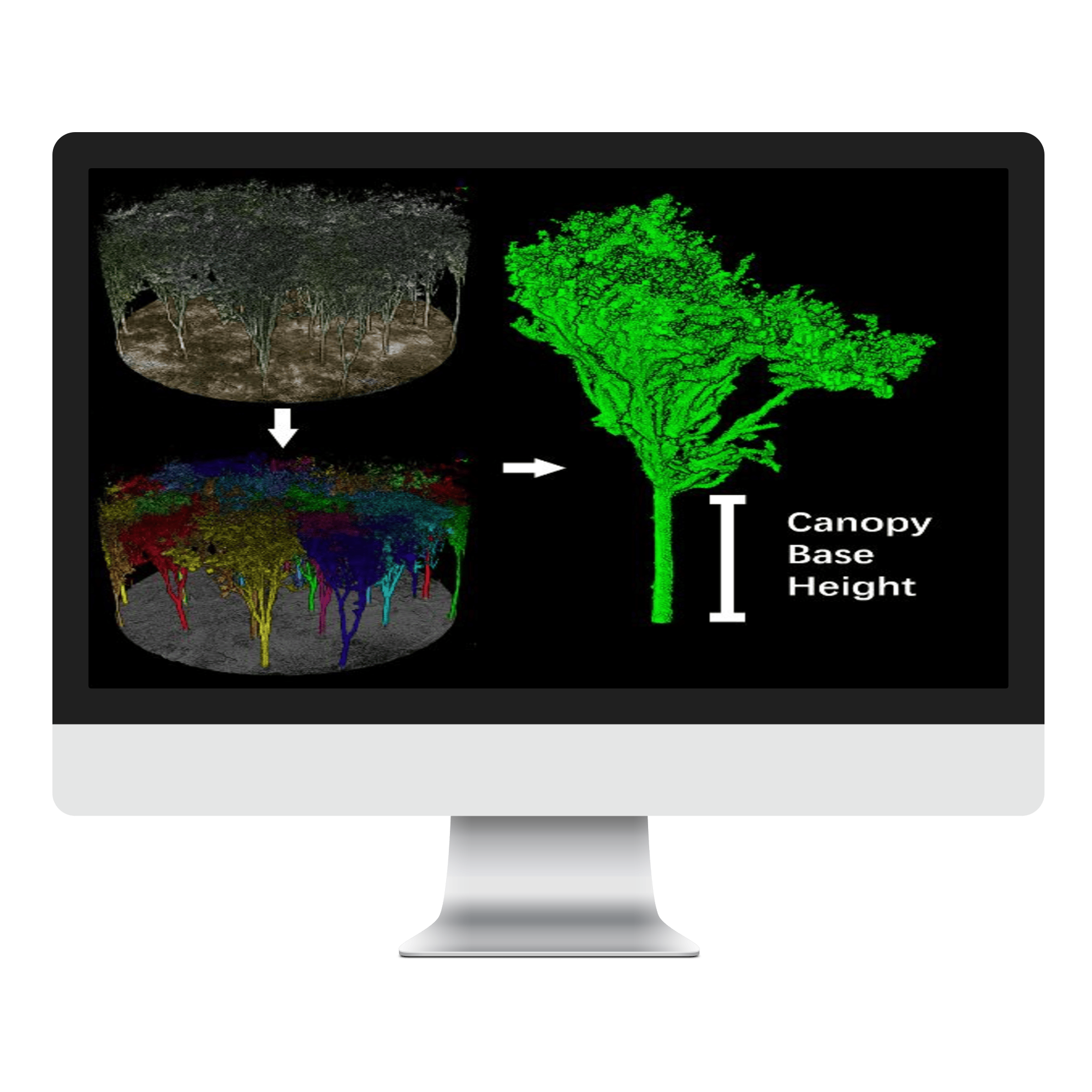
Forestry & Carbon Markets.
By use of drones mounted with LiDAR sensors, forestry data can be collected and processed to derive information crucial to forestry and carbon markets such as:
- Count individual trees for forest inventory & management.
- Measure individual tree heights.
- Measure individual tree diameter at breast height(DBH).
- Measure individual tree crown width, and trunk volume which aid in above-ground biomass calculations for Carbon Credits.
- Measure forest canopy density and clearance rate.
Agricultural Applications.
By use of drones mounted with high-resolution RGB cameras and multispectral sensors, data collected can be used to detect and quantify crop health problems early on. These valuable insights can reduce input costs and boost yield.
- Crop scouting: A quality drone and multispectral camera system can detect disease and stress early (sometimes before it is visible from the ground or with standard color cameras). This information, coupled with proven agronomic methods, to focus your treatment plans.
- Prescription maps and treatment plans: Multispectral data is a key tool that, when combined with other established agronomic methods, enables prescription maps for treatments (fertilizer, herbicide), reducing costs and improving efficiency.
- Irrigation monitoring and planning: Use drone maps, digital surface models, and terrain models for irrigation and drainage management. Multispectral data can also help identify leaky irrigation pipes or areas that need more water.
- Crop damage assessment and documentation: Drone data provides critical information for measuring and documenting damage to crops caused by floods, fire, pests, weather events, etc. These reports can complement and reinforce insurance claims.
- Plant counting and crop emergence: High resolution cameras on drones, and plant-counting algorithms can accurately and efficiently provide inventory information, track crop emergence, drive replanting decisions and help predict yield.
Services
Location data collection, visualization and analytics.
Custom cloud-based GIS software development.
Drone mapping and land surveying.
Satellite imagery-based monitoring &analytics.
Cloud geospatial data storage and hosting.
Mobile GIS data collection application software development.
Drone data processing & analytics.
Open source spatial data infrastructure architecture consulting.
Contact
Reach out on any of the channels below:
Our Address
1870 Sliproad off Waiyaki Way Westlands, Nairobi, Kenya
Email Us
info@polardot.co.ke